Rendered at 14:33:10 03/02/25

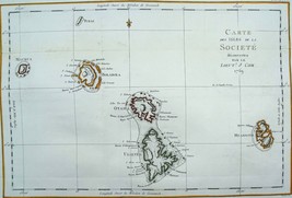
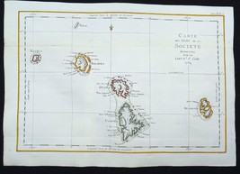
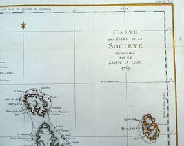
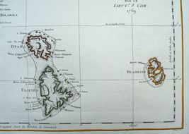


French Polynesia, Society Islands, map by Benard/Cook, 1774, Carte des Isles..
Ships from
Spain

Shipping options
Estimated to arrive by Thu, Mar 20th.
Details
£11.90 via International Shipping (2 to 3 weeks) to Worldwide
Ships from
Spain
Offer policy
OBO - Seller accepts offers on this item.
Details
Return policy
Full refund available within 30 days
Purchase protection
Payment options
PayPal accepted
PayPal Credit accepted
Venmo accepted
PayPal, MasterCard, Visa, Discover, and American Express accepted
Maestro accepted
Amazon Pay accepted
Nuvei accepted
Item traits
| Category: | |
|---|---|
| Quantity Available: |
Only one in stock, order soon |
| Condition: |
Used |
| Type: |
Nautical Map |
| Original/Reproduction: |
Antique Original |
| Date Range: |
1700-1799 |
| Year: |
1774 |
| Country/Region: |
French Polynesia |
| Format: |
Atlas Map |
| Printing Technique: |
Copper Plate |
| Cartographer/Publisher: |
Cook |
Listing details
| Seller policies: | |
|---|---|
| Shipping discount: |
No combined shipping offered |
| Posted for sale: |
February 27 |
| Item number: |
1725418980 |
Item description
Added to your wish list!

- French Polynesia, Society Islands, map by Benard/Cook, 1774, Carte des Isles..
- 1 in stock
- Price negotiable
- Handling time 1 day. Estimated delivery: Thu, Mar 20th
- Returns/refunds accepted
Get an item reminder
We'll email you a link to your item now and follow up with a single reminder (if you'd like one). That's it! No spam, no hassle.
Already have an account?
Log in and add this item to your wish list.